WMS - Web Map Service Development Guide
A WMS request defines the geographic layer(s) and area of interest to be processed. The response to the request is one or more geo-registered map images (returned as JPEG, PNG, etc) that can be displayed in a browser application. The interface also supports the ability to specify whether the returned images should be transparent so that layers from multiple servers can be combined or not.
WMS GetCapabilities request.
A request which returns a service metadata document (XML) describing the WMS service as well as valid operations and parameters provided by a single map file.
Required parameters:
project: name of directory where mapfile exists
map: name of mapfile to be used in request
service: name of protocol (WMS)
request: name of Maptimus 2 service operation (GetCapabilities)
Optional parameters:
version: protocol (WMS) version number (1.0.0, 1.0.7, 1.1.0, 1.1.1, 1.3.0)
format: output format of the response to a GetCapabilities operation
URL example:
https://maptimus.certusview.com/api/v2/mapserver?project=tests&map=osm-tests-wms&service=WMS&version=1.3.0&request=GetCapabilities
Output example :
<?xml version='1.0' encoding="UTF-8" standalone="no" ?
<WMS_Capabilities version="1.3.0" xmlns="http://www.opengis.net/wms" xmlns:sld="http://www.opengis.net/sld" xmlns:xsi="http://www.w3.org/2001/XMLSchema-instance" xmlns:ms="http://mapserver.gis.umn.edu/mapserver" xsi:schemaLocation="http://www.opengis.net/wms http://schemas.opengis.net/wms/1.3.0/capabilities_1_3_0.xsd http://www.opengis.net/sld http://schemas.opengis.net/sld/1.1.0/sld_capabilities.xsd http://mapserver.gis.umn.edu/mapserver https://maptimus-dev.certusview.com/api/v2/mapserver?project=tests&map=osm-tests-wms&service=WMS&version=1.3.0&request=GetSchemaExtension"
<!-- MapServer version 7.6.4 OUTPUT=PNG OUTPUT=JPEG OUTPUT=KML SUPPORTS=PROJ SUPPORTS=AGG SUPPORTS=FREETYPE SUPPORTS=CAIRO SUPPORTS=SVG_SYMBOLS SUPPORTS=RSVG SUPPORTS=ICONV SUPPORTS=FRIBIDI SUPPORTS=WMS_SERVER SUPPORTS=WMS_CLIENT SUPPORTS=WFS_SERVER SUPPORTS=WFS_CLIENT SUPPORTS=WCS_SERVER SUPPORTS=SOS_SERVER SUPPORTS=FASTCGI SUPPORTS=GEOS SUPPORTS=POINT_Z_M SUPPORTS=PBF INPUT=JPEG INPUT=POSTGIS INPUT=OGR INPUT=GDAL INPUT=SHAPEFILE --
<Service
<NameWMS</Name
...
</Style
</Layer
</Layer
</Capability
</WMS_Capabilities
WMS GetMap request.
A request which returns map data rendered as an image.
The following formats can be an output of the GetMap request:
JPEG: format=image/jpeg (default)
PNG: format=image/png
PDF: Format=application/x-pdf
MVT: format=application/x-protobuf
KML: format=application/vnd.google-earth.kmz
Required parameters:
project: name of directory where mapfile exists
map: name of mapfile to be used in request
service: name of protocol (WMS)
request: name of Maptimus 2 service operation (GetMap)
version: protocol (WMS) version number (1.0.0, 1.0.7, 1.1.0, 1.1.1, 1.3.0)
format: output format of the response to a GetMap operation
layers: comma-separated list of one or more map layers
styles: comma-separated list of one rendering style per requested
layer
crs: coordinate reference system of the spatial dataset
bbox: bounding box corners (lower left, upper right) in CRS units
width: width in pixels of map picture
height: height in pixels of map picture
Optional parameters:
transparent: background transparency of map (TRUE or FALSE)
bgcolor: hexadecimal red-green-blue color value for the background
color
URL example:
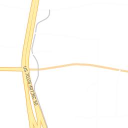
https://maptimus.certusview.com/api/v2/mapserver?project=tests&map=osm-tests-wms&service=WMS&version=1.3.0&request=GetMap&layers=test_roads&styles=&crs=EPSG:4326&bbox=35.727097,-78.653373,35.736211,-78.642274&width=256&height=256&format=image/png&transparent=true
Output example :
WMS GetFeatureInfo request.
An operation which returns feature information for any spatial data rendered on a particular pixel from an image returned from a GetMap request.
The following formats can be an output of the GetMap request:
GML
HTML
Required parameters:
project: name of directory where mapfile exists
map: name of mapfile to be used in request
service: name of protocol (WMS)
request: name of Maptimus 2 service operation (GetFeatureInfo)
version: protocol (WMS) version number (1.0.0, 1.0.7, 1.1.0, 1.1.1, 1.3.0)
info_format: output format of the response to a GetFeatureInfo operation
layers: comma-separated list of one or more map layers
query_layers: comma-separated list of one or more layers to be queried
i: coordinate in pixels of feature in Map CS (pixel column)
j: coordinate in pixels of feature in Map CS (pixel row)
Optional parameters:
feature_count: number of features about which to return information
URL example:
https://maptimus.certusview.com/api/v2/mapserver?project=tests&map=osm-tests-wms&service=WMS&version=1.3.0&request=GetFeatureInfo&layers=test_roads&query_layers=test_roads&crs=EPSG:4326&bbox=35.727097,-78.653373,35.736211,-78.642274&width=256&height=256&info_format=text/plain&i=64&j=64
Output example :
GetFeatureInfo results:

Layer 'test_roads'
  Feature 21:
    id = '3654295'
    osm_id = '18901281'

...

    draw_layer = '0'
    sidewalk = 'none'
    surface = 'paved'
    access_type = 'yes'
    service = 'none'
WMS GetStyles request.
An operation which returns a Styled Layer Descriptor (SLD) metadata document which describes style definitions that can be used in subsequent WMS requests or to style data in a client application.
Required parameters:
project: name of directory where mapfile exists
map: name of mapfile to be used in request
service: name of protocol (WMS)
request: name of Maptimus 2 service operation (GetStyles)
version: protocol (WMS) version number (1.0.0, 1.0.7, 1.1.0, 1.1.1, 1.3.0)
layers: comma-separated list of one or more map layers
URL example:
https://maptimus.certusview.com/api/v2/mapserver?project=tests&map=osm-tests-wms&service=WMS&version=1.1.0&request=GetStyles&layers=test_roads
Output example :
<StyledLayerDescriptor version="1.1.0" xsi:schemaLocation="http://www.opengis.net/sld http://schemas.opengis.net/sld/1.1.0/StyledLayerDescriptor.xsd" xmlns="http://www.opengis.net/sld" xmlns:ogc="http://www.opengis.net/ogc" xmlns:se="http://www.opengis.net/se" xmlns:xlink="http://www.w3.org/1999/xlink" xmlns:xsi="http://www.w3.org/2001/XMLSchema-instance">
    <NamedLayer>
        <se:Name>test_roads</se:Name>
        <UserStyle>
            <se:FeatureTypeStyle>

...

                </se:Rule>
            </se:FeatureTypeStyle>
        </UserStyle>
    </NamedLayer>
</StyledLayerDescriptor>
WMS GetLegendGraphic request.
A request which returns a Legend graphic for a specific WMS map file.
Required parameters:
project: name of directory where mapfile exists
map: name of mapfile to be used in request
service: name of protocol (WMS)
request: name of Maptimus 2 service operation (GetLegendGraphic)
version: protocol (WMS) version number (1.0.0, 1.0.7, 1.1.0, 1.1.1, 1.3.0)
format: output format of the response to a GetLegendGraphic operation
layers: name of layer
sld_version: version for SLD-specification
Optional parameters:
style: name of style
width: positive integer pixel width of desired output
height: positive integer pixel height of desired output
URL example:
https://maptimus.certusview.com/api/v2/mapserver?project=tests&map=osm-tests-wms&service=WMS&version=1.3.0&request=GetLegendGraphic&layer=test_roads&format=image/png&sld_version=1.1.0
Output example :
GetFeatureInfo results:

Layer 'test_roads'
  Feature 21:
    id = '3654295'
    osm_id = '18901281'

...

    draw_layer = '0'
    sidewalk = 'none'
    surface = 'paved'
    access_type = 'yes'
    service = 'none'
WMS DescribeLayer request.
An operation which returns a metadata document describing a specific layer of a map file.
Required parameters:
project: name of directory where mapfile exists
map: name of mapfile to be used in request
service: name of protocol (WMS)
request: name of Maptimus 2 service operation (GetLegendGraphic)
version: protocol (WMS) version number (1.0.0, 1.0.7, 1.1.0, 1.1.1, 1.3.0)
layers: name of layer
sld_version: version for SLD-specification
URL example:
https://maptimus.certusview.com/api/v2/mapserver?project=tests&map=osm-tests-wms&service=WMS&version=1.3.0&request=GetLegendGraphic&layer=test_roads&format=image/png&sld_version=1.1.0
Output example :
GetFeatureInfo results:

Layer 'test_roads'
  Feature 21:
    id = '3654295'
    osm_id = '18901281'

...

    draw_layer = '0'
    sidewalk = 'none'
    surface = 'paved'
    access_type = 'yes'
    service = 'none'